Water Wise Woodlands
Water Wise Woodlands is a partnership project between the Central Vermont Regional Planning Commission, Friends of the Winooski River, the Vermont Woodlands Association and VT Dept. of Forests, Parks, and Recreation; with funding from the High Meadows Fund.
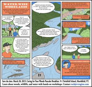
Whether you have 5 or 500 acres of woodland, you can help prevent flood damage and produce one of Vermont’s most important forest products—clean water! Healthy woodlands can absorb, slow down, and filter rain and storm water. Starting at the waters’ source, woodland owners in the Winooski Headwaters can be good stewards of the landscape, ensuring a healthy environment. With funding from the High Meadows Fund, CVRPC has partnered with Vermont Woodlands Association, Friends of the Winooski, and Winooski Headwaters Community Partnership.
A pancake breakfast and workshops were held on Saturday, March 30th at Twinfield Union School with over 70 attendees. Professional foresters and other experts shared information about how to care for woodlands, wildlife, and protect water resources. Delicious food, fun crafts, great community and learning. See the pictures.
Great doorprizes were donated by the following businesses: Lenny’s, R&L Archery, VT Woodlands Association, Perfect Circle Nursery, Cabot Creamery
See the Press Release for more information.
Also as part of this partnership several area residents joined us for three walks in the woods this fall to learn more about forest stewardship activities taking place in the Upper Winooski Watershed.
See some great pictures from our walks in Marshfield, Plainfield & Cabot.
https://plainfieldvt.wordpress.com/2018/10/14/sugarwoods-walk-in-marshfield/
https://plainfieldvt.wordpress.com/2018/10/21/tree-farm-walk-in-cabot/
https://plainfieldvt.wordpress.com/2018/10/29/forest-walk-in-plainfield/
Forest and Woodland Owner Resources:
Planning For Your Woods
Planning is one of the most important steps to your success as a steward of the woods. A plan provides you with a framework or a road map for visualizing the future. It helps you understand the condition of your forest, identify your goals, and prioritizes actions you can take to help improve and protect your property. Developing and following a plan will ensure that your property and its resources will be healthy and productive for future generations. Don’t forget that planning is a continuous process. Your plan should be updated regularly to account for changes in your objectives or changing forest conditions. For more information visit: https://www.ourvermontwoods.org/topic/planning
Backyard Woods Program
Do you own less than 25 acres and are interested in learning more about your woods? Do you want to become a more active steward of your woods? Then you may be interested in the Backyard Woods Program. The Vermont Backyard Woods Program is a six-week online program that, using a combination of videos, webinars, discussion forums, and weekly activities, explores the themes of getting to know your woods and developing an action plan. For more information visit: https://vtcommunityforestry.org/program/education/backyard-woods-program
Use Value Appraisal (Current Use)
Vermont‘s Use Value Appraisal (UVA) Program (also known as “Current Use”) enables eligible private lands where owners practice long-term forestry or agriculture to be appraised based on the property’s value of production of wood or food rather than its residential or commercial development value. The Department of Taxes, Division of Property Valuation and Review (PV&R) is the lead agency, but the County Foresters help to administer the Forestry Use Value Appraisal portion of the program. For more information visit: http://fpr.vermont.gov/forest/your_woods/use_value_appraisal
Forest Stewardship Program
The Forest Stewardship Program is a nationwide effort led by the US Forest Service and implemented through State Forestry organizations. The purpose of the Forest Stewardship Program is to help family forest owners with advice and assistance in caring for and enjoying their woodlands. Forest Stewardship is supported in Vermont through the County Foresters who can help landowners with guidance for plans that address multiple values.
Forest Stewardship Plans are required for properties enrolled in Vermont’s Forest Legacy Program, and Practice Programs through the Natural Resources Conservation Service. Plans written to Tree Farm standards also qualify as Forest Stewardship Plans for properties 10 acres and above. Plans written for Vermont’s Use Value Appraisal program qualify as Forest Stewardship Plans if they take water, wildlife, and ecosystems into consideration for management. A Forest Stewardship Plan can help landowners qualify for practice programs through the Natural Resource Conservation Service (NRCS) and may enable qualification in other private forestry programs and projects. For additional information visit: http://fpr.vermont.gov/forest/your_woods/stewardship
Forest Management Plans
Your forest management plan is the written story of your woodlands. It contains the hopes and dreams you have for your land and chronicles changes to your woods over time. Forest management plans are important because they list goals and outcomes, whether you are building a trail or cutting enough firewood to heat your home every year.
Forest management plans always include maps. Maps display the property boundaries of your land, the location of different forest stands (groups of trees of similar type and age), roads, trails, and streams. Other features noted on maps are hills, wetlands, openings, and buildings within the forest, as well as a size approximation and location of your woods within the larger landscape of the forest.
Even if you hire someone else to draft your forest management plan, the plan should indicate what you value most in the parcel and would like to enjoy over time. A professional can perform an inventory on your land to determine the resources present before any plan writing begins. Many consulting foresters write plans and later help the landowners implement them by overseeing harvesting, road construction, invasive plant control, or wildlife habitat improvement. For more information visit: http://fpr.vermont.gov/forest/your_woods/mgmt_plans
Cost Share and Incentive Programs
Cost share and incentive programs designed for forest landowners are valuable ways for landowners to accomplish conservation work on their land. The program offerings are subject to change over time; to stay abreast, check websites, landowner groups, and newsletters often.
The main federal agencies that currently provide funding for specific management activities on private lands are the Natural Resource Conservation Service (NRCS) and the Farm Services Agency (FSA).
The NRCS provides funding for forest plans and forest improvement work through their Environmental Quality Incentive Program (EQIP). They also provide funding for wildlife habitat, and road and trail improvement to protect or improve water quality.
Some forest landowners may also qualify for technical assistance on managing lands deemed valuable for wildlife habitat through the Vermont Fish & Wildlife Department or US Fish and Wildlife Service.
Landowners who host specific types of recreation trails on their property may qualify for trail corridor management labor from local trail organizations. Contact VT Trails or Greenways Program or your town conservation commission for organizations who operate in your area. For more information visit: http://fpr.vermont.gov/forest/your_woods/cost_share
Water Wise Woodlands Partners
Friends of the Winooski River – The Friends is a volunteer group dedicated to the protection and restoration of the Winooski River, its tributaries and watershed. From its headwaters in Coits Pond in Cabot, the Winooski River flows ninety miles to its mouth in Lake Champlain in Colchester. For additional information visit: https://winooskiriver.org/
Central Vermont Regional Planning Commission – The mission of the Central Vermont Regional Planning Commission (CVRPC) is to assist member municipalities in providing effective local government and to work cooperatively with them to address regional issues. CVRPC can assist municipalities in the development of Town Plans and land use regulations, such as zoning and subdivision. The RPC also can assist with GIS analysis and map development. For additional information visit: https://centralvtplanning.org/
Vermont Woodlands Association – a nonprofit corporation whose mission is to advocate for the management, sustainability, perpetuation, and enjoyment of forests through the practice of excellent forestry that employs highly integrated management practices that protect and enhance both the tangible and intangible values of forests – including clean air and water, forest products, wildlife habitat, biodiversity, recreation, scenic beauty, and other resources – for this and future generations. VWA objectives are to communicate the benefits of working forests, recognize exemplary actions of woodland owners and managers, provide educational opportunities, and to represent its membership before governmental bodies. The Vermont Woodlands sponsors the Tree Farm Program in Vermont and sponsors peer-to-peer network and Walk In the Woods events. For more information visit: http://www.vermontwoodlands.org/
Winooski Headwaters Community Partnership brings together the Winooski Watershed towns of Cabot, Marshfield, and Plainfield to coordinate watershed restoration work in the headwaters of the Winooski River. The Partnership is supported by Cabot Creamery. For more information visit: https://winooskiriver.org/headwaters.php
Other Related Organizations and Associations
Vermont Maple Sugar Makers Association
Winooski Natural Resource Conservation District
FEMC (Forest Ecosystem Monitoring Cooperative)
Vermont-Based Reports
Planning for Flood Recovery and Long-Term Resilience in Vermont: https://www.epa.gov/sites/production/files/2014-07/documents/vermont-sgia-final-report.pdf
Relevant Recommendations include:
- Adopt tree protection measures
- Adopt steep slope development regulations
- Adopt riparian and wetland buffer requirements
State Lands and Flood Resilience – Challenges and Opportunities A Blueprint for Enhancing Flood Resilience and Improving Water Quality on ANR Lands ANR Lands Stewardship Team June, 2016:
Generalized applicable Short Term Actions (regarding Guidelines, Standards, and Practices):
- Promote implementation of new ANR Riparian Management Guidelines.
- Provide water resource rules and flood resilience training to landowners.
- Develop “optimal conservation practices” (OCPs) for enhancing flood resilience and water quality in forested watersheds.
Vermont’s Roadmap to Resilience: Preparing for Natural Disasters and the Effects of Climate Change in the Green Mountain State, 2013: https://resilientvt.files.wordpress.com/2013/12/vermonts-roadmap-to-resilience-web.pdf
Applicable recommendations:
- Engage private landowners as key partners to implement land management practices that reduce hazards and support healthy ecosystems.
- Use regional networks to support watershed-scale planning and enable municipalities to collaborate across jurisdictions to set priorities and make cost-effective investments that reduce hazards for downstream communities and development.
- Support local resilience networks that bring together planning boards, conservation commissions, emergency managers, social service providers and other leaders to develop a shared vision for resilience within a community.
- Invest in education and outreach to increase public literacy regarding river science and floodplain management practices.
Creating and Maintaining Resilient Forests in Vermont: Adapting Forests to Climate Change, May 2015: http://fpr.vermont.gov/sites/fpr/files/Forest_and_Forestry/Forest_Health/Library/Climate%20change%20report_final_v6-18-15a.pdf
Applicable recommendations:
- Forest Adaptation Strategies for All Forests – Increase forest cover in riparian areas and upland forests adjacent to riparian areas and wetlands to moderate stream temperatures, maintain wildlife corridors, and mitigate flooding impacts.
- Natural Community Adaptation Strategies – Promote landscape connectivity. Protection of the stage was mentioned earlier, but protection alone is insufficient. Connecting intact areas of forest across an increasingly developed landscape is essential. Landscape-level planning; identification of critical connecting landscapes; and protection of these landscapes through land use, zoning, and conservation easements should be priorities. At local scales, riparian area corridors can be restored by expanding forest cover from adjacent forests. Likewise, habitat corridors along field edges and in abandoned farmland could be enhanced through reforestation. Increased funding would facilitate the purchase of conservation easements. A conservation community should not overlook the eligibility of aggregated small parcels to create connected landscapes.
Additional Data and Research
- Sustaining Family Forests Initiative (research and resources on effectively engaging landowners):https://sffi.yale.edu
- Focus Group Study: Motivating Woodland Owners to Take Action:
https://sffi.yale.edu/sites/default/files/files/SFFI%20Focus%20Group%20Findings%20October%202014.pdf
- Focus Group Report: Reaching Woodland Owners with Messages that Resonate:
https://sffi.yale.edu/sites/default/files/files/SFFI%20Focus%20Group%20Report%20-
%203%20Call%20Before%20You%20Cut%20states(1).doc
- Family Forest Owners Literature Review:
https://sffi.yale.edu/sites/default/files/files/Resources/Family%20Forest%20Owners%20-
%20Lit%20Review2011%20copy.pdf
- Shaping Pro-Environment Behaviors Study: http://www.apa.org/research/action/shaping.aspx
- The Nature Conservancy’s Conservation Campaign Resources:
https://www.nature.org/ourinitiatives/habitats/riverslakes/wftoolkit-conservation-cmpgns.xml?redirect=https-301


